For this second report, I selected again one local, one German-wide, and one global initiative. One of these initiatives is “dead”, find out why!
Velogistics: a map for sharing cargo bikes (global)
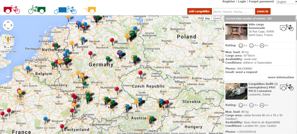 Velogistics is a simple map interface that allows you to find a cargo bike around where you live. With almost 200 bikes registered across the world (most are in Germany), it is a working prototype that applied the sharing approach to the issue of mobility: in that case for transporting cargos!
It was started in 2011 by Tom Hansing in his free time. His motivation was to be able to share his own cargo bikes and allow others to do the same. Indeed, as all those who commute with their bikes only, transporting heavy loads is an issue. The cargo bike offers a great alternative to fossil fueled solutions. Built with simple available code, the platform is simple but efficient allowing to find in a few clicks a telephone number and conditions for borrowing or renting such a bike. With no active promotion the platform has spread beyond German borders and is available in German, French and English. If Tom had the time to do so he would further develop and promote the platform, including by enabling exchange of data with other sharing platforms. If you want to give a hand, contact him!
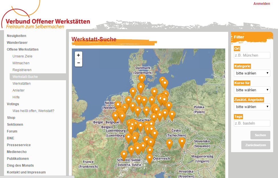
The map of open DIY workshops (Germany)
That map shows the location of over 80 open coops where you can find tools to build or repair yourself pretty much anything from a cargo-bike to upcycled furniture or 3D print objects. On this map you’ll find FabLabs, makerspaces, printing coops, or good old workshops as they exist for years. It is maintained by German Association of open workshops (Verbund Offener Werkstaetten). This map is born from the will of the Anstiftung & Ertomis and several local initiatives to make open workshops, in all their diversity, more visible for the public as well as (local) policy makers. Thus, if you want to build a bed with old pallets and have no tools or clue, it may be a good start to check that map. In those workshops there are always some skilled volunteers ready to share their expertise and teach yound padawans. Online, any initiative can register itself as long as it fits the definition of an open workshop, create a profile and appear on the map. They are then encouraged to join the association without being obliged to.
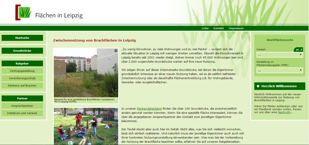
Flaechen-in-Leipzig (local)
Created in 2005 this platform is kind of retired. Indeed, during the early years of 2000, Leipzig was a city that was still suffering of a very long period of demographic and economic shrinking, losing over a third of its population. As a consequence, plenty of land was just abandoned, nobody having the resources to maintain it, not to say to develop it. In response the municipality (Amt für Stadterneuerung und Wohnungsbauförderung) in cooperation with consultancies and a civil society organization (Bürger Stiftung Leipzig) put together an online platform where citizens (and developers) could find vacant lots and specific information on ways to use them as playgrounds or community gardens. Data from the local government was used and refined. A map was set up to visualize and easily locate each lot. For some time now the map is not working as Google change its Maps technical specifications and no resource is available for fixing it. Data is also not maintained anymore. In fact, as now Leipzig is a booming city, the problem of brown field and vacant land disappeared. But, while the webpage was almost scrapped a couple of times, some have advocated to keep it online letting the door open to a revival…
ABOUT GOVERNANCE
Community
Those three cases covers very different organizational backgrounds, but in all of them, men have been in charge. In the case of Velogistics, the platform is provided by a private person who responds to contributors suggestions (including the translation of the interface in two languages). It brings together owners of cargo bikes in a very loose context, functioning a specialized yellow pages directory – being specialized means you can find it by searching online for cargo bikes…
The case of the open workshops’ map is slightly different as it depicts an actual network of initiatives represented by a formal association, having its dedicated communication channels (mailing lists). But its directory is also open to any like-minded initiatives. In both those cases we can distinguish the users of the platforms just consulting information and the participants, providing simple data.
In Leipzig, there is no community at all, the platform was set up by the city administration using existing data in a more traditional top-down project management fashion. Paradoxically, being funded by public money may be a severe constraint for the sustainability of the platform over time…
Again, not one woman behind those maps (to my knowledge).
Resource
All three maps are mapping points of interests (POIs): bikes, initiatives, land lots. The nature of the data being stored is very similar: mainly address, contact details, description, conditions of access (availability and financial conditions, opening hours, ownership). Two of the cases use the Google Maps infrastructure. In the case of Flaechen-in-Leipzig, there was at the time no alternative. Ten years later, it’s broken down. Velogistics uses Google Maps as it was at the time the easiest technical solution for a non-programmer to set up such a platform. The open workshops online platforms is more advanced as it is being developed by an association. Interestingly, as a consequence of their commitment to open resources, its members chose to make the transition from a Google-powered map to OpenStreetMap, even when it was incurring an additional cost.
Rules
In the case of Velogistics and the open workshops maps, the crowd can add new entries/POIs. Any contribution that doesn’t fit the simple eligibility guidelines are systematically ejected from the map, to preserve its coherence and purpose. Admins are implementing those rules.
Sharing data? Flaechen-in-Leipzig uses public information. Implicitly it is public domain, however nothing is mentioned on the platform and the usual copyright disclaimer are ambiguous. In the two other cases the map admin never really thought about applying a license to the data. While they are generally very much in favour of seeing their data being used, sharing contact details with other platforms is seen as problematic.
People shared their contact details in a specific context. I don’t feel comfortable in seeing this data being published in a different context says Tom Hansing (Velogistics and Verbund Offener Werkstaetten)
Beyond that, sharing data across platforms may require technical skills that an initiative like Velogistics doesn’t have: thus Tom had couldn’t respond to an offer to appear on the Sharingcityberlin map.
WHAT IMPACT?
In Leipzig the map of vacant land was part of a larger effort by the municipality to encourage land use. From the partial information we have, it seems the platform helped more investors to identify available land rather than self-organized groups to start community gardens. It is therefore hard to evaluate the impact of such platform. From our first assessment, it seems that the lack of a community associated to the platform (like in the case of Living Lot) may explain that the platform had actually little impact in supporting the development of alternative uses such as community gardening.
Velogistics does enable sharing of cargobikes. However, it is very difficult to evaluate how many people use the platform, as contact details are publicly visible and users don’t necessarily post a review after borrowing a bikes. It is interesting to see that the platform is being used by some pioneers across the world without much effort made by its creator to expand.
The map of German open workshops may be the one where the impact is the more substantial. Indeed, it functions as a directory for a large diversity of people who are looking to build or repair themselves or just share their knowledge. Interestingly, the platform is very much used by the initiatives themselves to network and exchange information directly. Indeed, Tom Hansing who is supporting its development says that such exchanges are crucial to ensure the transfer of the implicit knowledge necessary to set up and run a coop. Furthermore, the map in the context of the website gives inspiration. It also provides some legitimacy to local initiatives in their debuts: being part of a wider movement, they are taken more seriously locally, helping to secure institutional support for instance. Eventually, the map itself is not insignificant in developing a common identity among the initiatives: the map was set up before the foundation of a nation-wide association…
One map to unify them all?
Initiatives like TransforMap are aiming at bringing a wide diversity of initiatives on a single map with the idea that a map of all transformative local intiatives would bring them more light. However, from his expertise Tom Hansing stresses the fact that specialized maps are easier to find with a search engine: indeed, it is unlikely that someone looking for a cargo-bike or a place to repair its bike finds a general map like TransforMap. In addition, such searches should provide results with very few clicks. Again, general purpose maps may fail to provide such seamless user experience. From then on, it may be useful to combine/connect specialized and general maps to maximize visibility.
Maps to match people
For Tom Hansing, one thing that is missing today is some applications allowing the matching of people according to location and joint interests. Thus, he is developing with his employer, the non-profit Anstiftung & Ertomis, a service to connect people who are geographically close from each other and interested in self-repairing. The idea is to encourage the creation of repairing initiatives and events to further develop that sustainable practice.
This is the second intermediary report of exploratory case-studies that I am conducting as part of a research on grassroots mapping initiatives that contribute to a socio-ecological transition. The research generally tries to answer two broad questions:
- How are such mapping initiatives self-governed or in other words how do groups of citizens co-create information through the use of maps?
- How is this information (maps) made operable in the real (offline) world? Does it support the diffusion of alternative practices (community gardening, CSA, sharing, etc.)?
This research is part of a PhD project (link) and contributes to inform the TransforMap initiative[1]. This report is based on two interviews and online research.
Thanks to Tom Hansing (Anstiftung & Ertomis) and Ralf Elsässer (CivixX – Werkstatt für Zivilgesellschaft) for their availability.

2 thoughts on “Field report #2: Maps to find DIY coops, share cargo bikes, and revitalize brown fields”